LOADING

Digitisation.

Acquire Data
and Digitise your assets

Explore

Digital Data Acquisition.

Laser Scanning / 3D modeling.

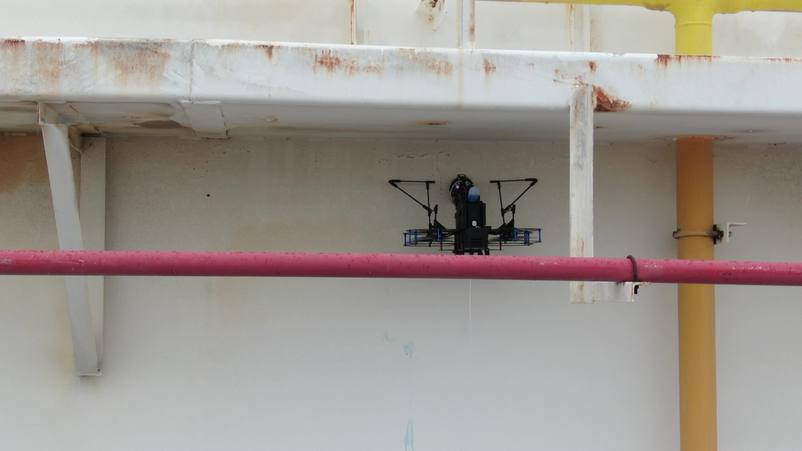
Working closely with our partners, Performance Rotors has combined Laser and Drone technologies to digitalise your assets for ease of Inspection, Maintenance and Repair. This allows for quick defect localisation, documentation and maintenance monitoring.

Reports

Dr.One solution.

A successful inspection will require a report that is
comprehensive, yet concise and easily understood.
This can be broken into 3 key aspects.

Sorting and analysing the
data collected

Certified Professionals to provide
their input

Consolidate all information to
generate report

AI Defect Reporting

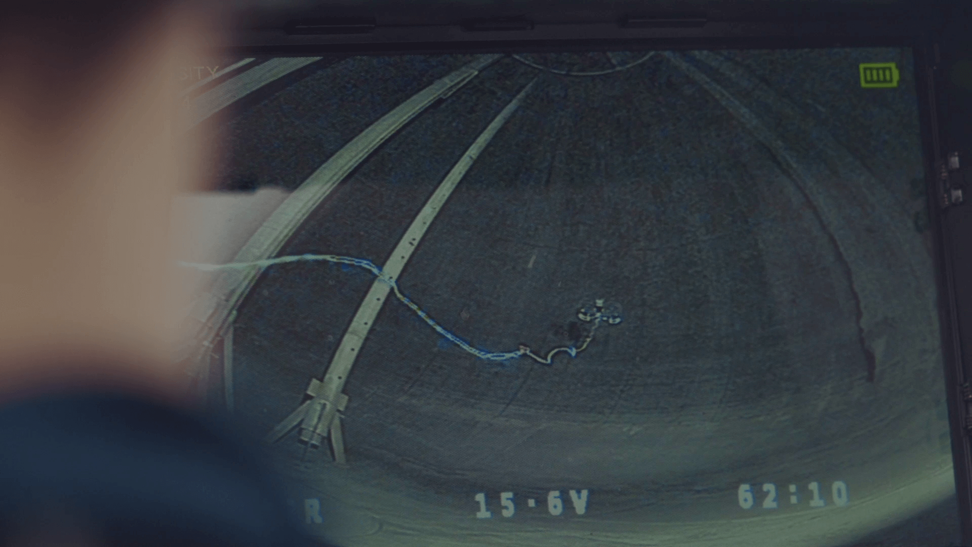
After the data from internal bulk tank inspections has been acquired by the drone, Performance Rotors’ proprietary AI will be used for fast defect detection and localisation. The report is then generated in digital format or in conventional PDF format for review.

Platform

Digital Twin.

The Falcker Platform

Falcker supports energy companies to achieve optimal returns from their investments in assets in a responsible way for people and environment.

In co-creation with various market players we have developed a Digital Asset Care Platform. Falcker’s platform is implemented at several industrial sites and digitizes inspection processes, which helps companies gain more control over their assets to secure safety, integrity and predictability.

System

Smart P&ID.

P&ID Drawings

A3D recognise point cloud technologies as the most effective methods of capturing 3D measured site data and have developed a unique point cloud to P&ID solution. Clients can view 3D models via standard Autodesk software, removing the need to purchase expensive specialist additions.

Coupling both A3D’s 30 year experience in designing P&IDs with modern technology, such as Autodesk’s Smart P&ID software, our customers benefit from faster drafting, consistent drawing standards across all their P&IDs and a proven solution to keep P&IDs as-built.

Data is collected via 3D laser scanning, offering a much quicker, cost-effective and higher quality solution than traditional surveying methods.

UTG Thickness Measurement.

Using our Raven-UTG drone, we are able to take Thickness Measurements

RAVEN UTG.

UTG Thickness Measurement.

Using our Raven-UTG drone, we are able to take Thickness Measurements

RAVEN UTG.

A Comprehensive Laser, Visual and Thermal data acquisition.

Visual & Thermal data digitalised onto a
3D Digital Twin platform.

TRIMBLE X7.

Speak

Our Custom Solutions.

Speak to our project managers today to find out how our solutions can be applied for your use case!

We harness the power of custom-designed drones, AI and data analytics to streamline operations, reduce costs, and eliminate hazards in heavy industries that is unparalleled by mainstream drones in the market.

Mini Cart 0

Your cart is empty.

Meet RAVEN-UTG, the smallest Ultrasonic Thickness Measurement drone

  • Mechanical & Electrically Protection
  • 01. Small 420x400mm 6″ propeller size
  • 02. Collision-Tolerant with guarded propeller frame design
  • 03. Isolated high power components for operations in Atex Zone2 environments (not Atex certified yet)
  • Operates in GPS Denied Environment
  • 01. Position Hold, Altitude Hold and all round Collision Avoidance
  • 02. Relative drone position available for inspection location identification
  • 03. Application base localisation for different environments and missions
  • 04. Operable in Dark Environments
  • 05. Tethered Power system up to 1hr flight time
  • High quality illuminated inspection camera
  • 01. Up to 4k30fps or 2k60fps recorded videos depending on mission requirements
  • 02. High intensity LED illumination for inspection/ navigation in pitch darkness
  • 03. Oblique lighting pattern for surface depth/ texture inspection
  • 04. Stabilized +/-90 degrees vertical axis adjustment camera for smooth recordings of roofs, walls and floors
  • Ultrasonic Thickness Gauge frame with multiple probe head options: Rolling Tank Shell / Pipes / 3-points
  • 01. Sound Velocity Range: From 1000 m/s to 8000 m/s (0.0394 in/μs to 0.3150 in/μs)
  • 02. Resolution: 0.1 mm (0.005”) or 0.05 mm (0.002”)
  • 03. Accuracy: ± 0.1 mm (0.005”) or ± 0.05 mm (0.002”)
  • 04. Coatings Range: Up to 6mm (Standard Mode)*; up to 20mm (Coating Plus+)*
  • 05. Couplant: Onboard couplant dispenser with quick change cartridge
  • 06. Speed: Up to 300 points per hour for external tank shell thickness measurements

Trimble X7 laser scanner

  • Professional System
  • 01. Automatic Calibration & Self-leveling
  • 02. Geo-referencing: Link registered scans to a project coordinate system
  • 03. Operating temperature between -20℃ to 50℃ / IP55 Rated / 4 hours of operating time per battery
  • Accurate laser for a reliable dataset
  • 01. Range: 0.6 - 80m
  • 02. Noise: <2.5mm at 30m
  • 03. Range Accuracy of 2mm
  • 04. 3D point accuracy of: 2.4mm @ 10m / 3.5mm @ 20m / 6.0mm @ 40m
  • 05. Up to 109 Million points per scan
  • Software
  • 01. Trimble perspective software allows for full on-site control and registration, which enables the job to be completed on-site
  • 02. Export data to a variety of established data format for Trimble and non-Trimble software suites

Meet RAVEN-VI, the smallest smart non-GPS assisted inspection drone

  • Compact mechanically and electrically protected airframe
  • 01. Small and compact 400*300mm 6.2” propeller frame
  • 02. Collision tolerant carbon fibre propeller guard design
  • 03. Isolated high power components for operations in zone 2 environments
  • Operates in GPS Denied Environment
  • 01. Onboard Position/ Altitude hold with responsive all round electronic collision avoidance
  • 02. Relative drone position available for inspection location identification
  • 03. Application base localisation for different environments and missions
  • High quality illuminated inspection camera
  • 01. Up to 4k30fps or 2k60fps recorded videos depending on mission requirements
  • 02. High intensity LED illumination for inspection/ navigation in pitch darkness
  • 03. Oblique lighting pattern for surface depth/ texture inspection
  • 04. Stabilized +-90 degrees vertical axis adjustment camera for smooth recordings of roofs, walls and floors
  • Multiple different configurations
  • 01. Visual Inspection Core - For visual inspections
  • 02. Customised Payload Core - Upon request
  • 03. Tethered/ Battery mode - All RAVEN models

DJI Matrice 300 RTK

  • Commercial drone platform
  • 01. Outdoor GPS Drone
  • 02. Anti-collision Sensors
  • 03. IP45 Rating
  • Transmission system
  • 01. 15 km Transmission range
  • 02. RC & Video frequencies 2.4GHz and 5.8GHz
  • 03. Max flight time of 55 mins
  • Payload: Zenmuse H20 Camera
  • 01. Hybrid camera which includes optical and thermal sensors
  • 02. 12MP Wide angle camera
  • 03. 20MP Zoom camera with 23x optical zoom
  • 04. 620 x 512 px Radiometric thermal camera
  • Payload: Zenmuse P1 Camera
  • 01. 45 MP Full-frame photography for Aerial Surveying
  • 02. High Global shutter speed of 1/2000 seconds
  • 03. TimeSync 2.0 allows for microsecond level of synchronization
  • 04. Fixed-focus 35mm len